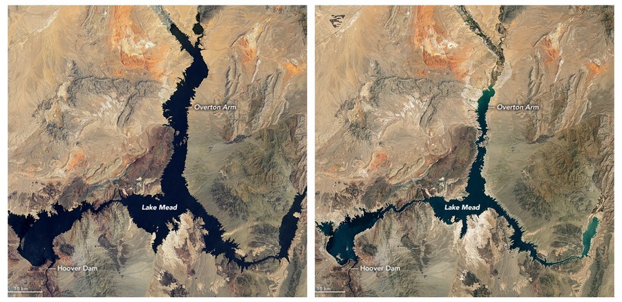
Combo photo taken by NASA satellites shows the water level change between July 6, 2000 (L) and July 3, 2022 in Lake Mead, Nevada, the United States. (Photo credit: NASA Earth Observatory)
Pictures taken from far above the planet show drastic water level drops in Lake Mead and Lake Powell and the tell-tale "bathtub rings" on canyon walls, which illustrate that water levels were dozens feet higher in just the past few years. The Colorado River system is down to 34 percent capacity, another drop from its 40 percent capacity last year.
DENVER, the United States, Aug. 22 (Xinhua) -- The record drought in America's Southwest can be seen from 35,000 kilometers above Earth.
Recently released surveillance from the National Aeronautical and Space Administration (NASA) showed areas where the historic "mega-drought" has left gigantic "bathtub rings" on the country's largest reservoirs and vast, parched areas, which now can be seen from outer space.
Federal officials announced new water cuts to states that rely on the Colorado River in a suite of emergency moves to reinforce reservoirs that have hit record-low levels due to climate change and decades of drought.
"In order to avoid a catastrophic collapse of the Colorado River System and a future of uncertainty and conflict, water use in the Basin must be reduced," said Tanya Trujillo, assistant secretary for water and science at the Department of the Interior, in a statement last Tuesday.
According to the latest plan, Arizona and Nevada would lose 21 percent and 8 percent respectively of their annual allotment of Colorado River water. Mexico, which also receives water from the river, will see its annual allotment reduced by 7 percent.
Earlier this summer, the federal government gave the states two months to figure out how to stop using 2 to 4 million acre-feet of Colorado River water to help prop up the reservoirs -- or face the prospect that the federal government would step in and make the cuts itself.
However, water managers in Arizona, California and Nevada last week failed to agree on a plan to cut water in the lower basin after weeks of heated negotiations.
The graphic images underscore the dire threat to some 40 million Americans in seven western states that an anticipated water shortage will create, and were released last week by NASA.com from its satellites that circumnavigate the globe from 35,000 kilometers high.
"NASA satellites have been monitoring waterways in the West for years and documenting how the region is drying up," Vox.com reported Friday.
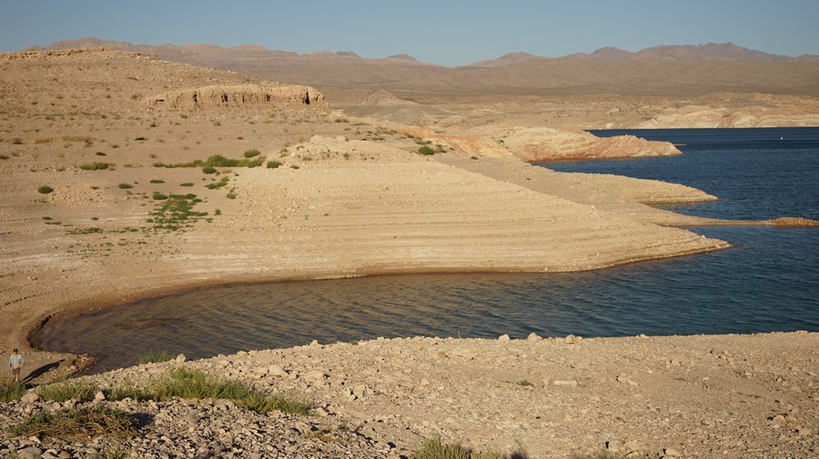
Photo taken on July 5, 2022 shows a white band of dried rocks around Lake Mead near Echo Bay in Nevada, the United States. (Photo by Zeng Hui/Xinhua)
"It's part of a trend lasting almost two decades, making it the worst drought in 1,200 years. Part of the severity of this 'mega-drought' has been worsened by climate change," the report added.
Pictures taken from far above the planet show drastic water level drops in Lake Mead and Lake Powell and the tell-tale "bathtub rings" on canyon walls, which illustrate that water levels were dozens feet higher in just the past few years.
The Colorado River system is down to 34 percent capacity, another drop from its 40 percent capacity last year.
Lake Mead, a reservoir held by the Hoover Dam and located between Nevada and Arizona, is the largest U.S. reservoir in water capacity and can hold 9.3 trillion gallons of water, a level not seen since 1999.
Two months ago, Lake Mead's water elevation fell to about 1,042 feet, a record low, and put the lake below 27 percent of its capacity. On Monday, the number is 1,043.43 feet.
If water levels in Lake Mead dip below 1,000 feet, the massive generators that produce more than 2,000 megawatts at their peak can no longer operate as normal. And if the drought continues, Lake Mead could reach dead pool status, where the water level is too low to flow downstream.
The situation is also bleak upstream along the Colorado River between Utah and Arizona where Lake Powell, formed by the Glen Canyon Dam, is also at record low water levels. As of Monday, its water level is 3,533.37 feet, 166.63 feet below full pool.
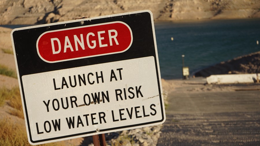
Photo taken on July 5, 2022 shows a sign warning people about the danger to launch boats due to low water levels near Echo Bay, Lake Mead, Nevada, the United States. (Photo by Zeng Hui/Xinhua)
Lake Powell can hold about 8.2 trillion gallons of water at its peak, but its current water levels fell below 25 percent of its full capacity.
Similar drops in mid-sized reservoirs have also gained NASA's eye and the concern of government officials who see them as critical examples of the need for drastic and dramatic reductions in water use.
In California, Shasta Lake, which holds 1.46 million gallons when full, is only 38 percent full, and Lake Oroville, with a peak capacity of 1.15 trillion gallons, also saw a big drop in water levels between 2019 and 2021.
In South Dakota, the Bureau of Reclamation and South Dakota Game, Fish and Parks, placed unprecedented restriction on Belle Fourche Reservoir.
"Restrictions are necessary due to the continued drought conditions and fire restrictions enacted ..." the agency said in a press release Friday.
And 850 miles southwest, in Colorado's "Four Corner" region, officials at McPhee Reservoir were chanting the same dismal tune.
"The reservoir is almost 100 feet below normal and even with the recent rain, it will take much more than this to combat the record drought," local officials told Xinhua, of their massive reservoir near Colorado's joint borders with Arizona, Utah, and New Mexico. ■