
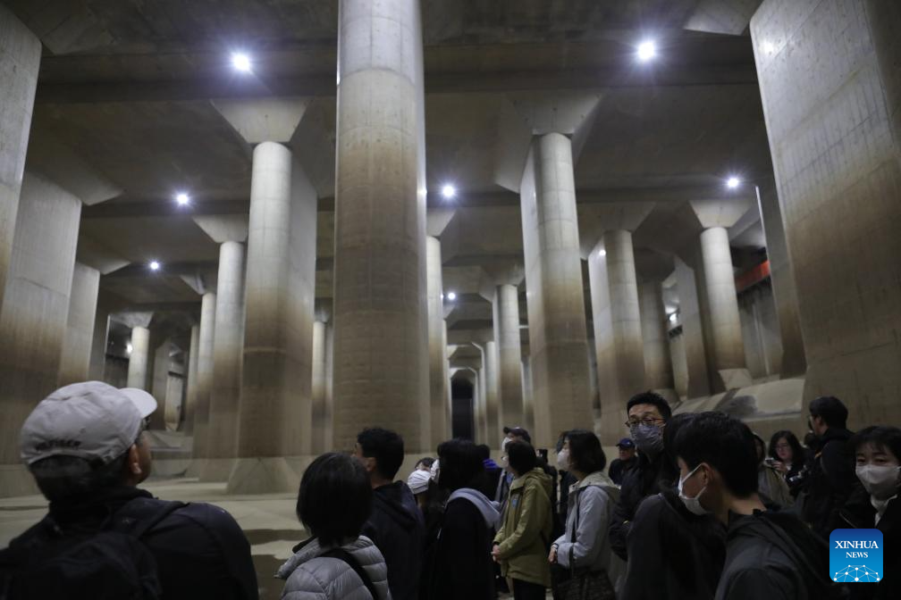
This photo taken on March 26, 2024 shows tourists from worldwide visiting the pressure-adjusting water tank in Japan's Saitama Prefecture.(Xinhua/Zhong Ya)
TOKYO, March 29 (Xinhua) -- RyuQkan is roughly a 30-minute walk from the Minami-sakurai railway station in Japan's eastern Saitama Prefecture. It is a museum, which introduces the Metropolitan Outer Area Underground Discharge Channel, one of the world's largest underground flood diversion systems.
A stair with more than 110 steps leads downward to an exploration and the pressure-adjusting water tank, which measures 177 meters long, 78 meters wide, and 18 meters high. The 59 concrete pillars there, each standing 2 meters wide, 18 meters high and weighing approximately 500 tons, support a massive underground space and earn the latter a nickname meaning disaster-prevention underground shrine.
The air is fresh inside the solid, well-designed underground concrete structure, which is a very impressive surprise. "Why are there many seams on the walls?" tourists may ask. In quite a standard answer, a female staff worker of the museum in her 30s, said, "Japan is a country prone to earthquakes. In order to reduce the risk of earthquake damage, the tank is built in parts and then joined by special materials."
"In this way, when an earthquake occurs, the whole building will not shake together, and the possibility of collapse is greatly reduced."
The tank is a key part of the Metropolitan Outer Area Underground Discharge Channel, which was built to mitigate flood damage in the Nakagawa River and Ayase River area. Surrounded by large rivers such as the Tone River, Edogawa River and Arakawa River, the area becomes a bowl-shaped basin where water easily accumulates.
When a downpour fills riverbeds, the overflow will be taken in by shafts, before being carried to the pressure-adjusting water tank by tunnels. After the tank reduces the force of the floodwater, it will be discharged into the Edogawa River by drainage pumps and sluiceways.
Operating for 18 years since its partial launch in 2002, the underground discharge channel has prevented flood damage amounting to approximately 148.4 billion Japanese yen (about 980.5 million U.S. dollars).
Notably, during Typhoon No. 19 in October 2019, the metropolitan area's peripheral drainage channels carried out the third-largest amount of flood control in history, about 12.18 million cubic meters, which reduced the number of flooded houses in the area by about 90 percent and reduced the damage by about 26.4 billion yen (about 174.4 million U.S. dollars).
The Metropolitan Outer Area Underground Discharge Channel is part of Tokyo's comprehensive measures to tackle floods. The Tokyo Megalopolis Region, or Greater Tokyo Area, made up of Tokyo and the three neighboring prefectures of Saitama, Chiba, and Kanagawa, is crisscrossed with rivers and streams, and to the south it borders Tokyo Bay by the Pacific Ocean.
Located in a temperate maritime climate, rainfall is abundant here, with an annual precipitation of about 1,700 millimeters, nearly twice the global average. During the typhoon season from July to October, heavy rainstorms occur frequently, often triggering floods.
Official records show that in September 1982, floods submerged nearly 30,000 households here; in September 2005, concentrated heavy rainfall of 112 millimeters per hour caused significant damage to the Suginami and Nakano wards of Tokyo.
Tokyo has always been stepping up its efforts to combat floods. Beneath its 2,194-square-kilometer land lie 16,000-kilometer sewage pipes in total -- a distance back and forth between Tokyo and Australia's Sydney -- as well as 58 rainwater storage facilities with a total capacity of 600,000 cubic meters.
The Tokyo Resilience Project, a megaproject to improve its disaster prevention infrastructure by the 2040s, also speaks loudly of the metropolis' determination to fight against natural disasters.
Under the project, a tunnel-shaped reservoir about 40 meters below the surface and stretching roughly 5.4 kilometers is being built in Tokyo's Nakano ward. When completed, it will link the Kanda River/Ring Road No. 7 and the Shirako River underground regulating reservoirs. The resulting space, some 13.1 kilometers in length and 1.4 million cubic meters in volume, will become the Asian country's largest subterranean regulation reservoir.
Yasunori Terui, chief of the engineering section 2 of the Fourth Construction Office, under the Tokyo Metropolitan Government Bureau of Construction, told Xinhua that the subterranean regulation reservoir being built will be able to manage intense rainfall with a precipitation rate of 100 millimeters per hour. ■
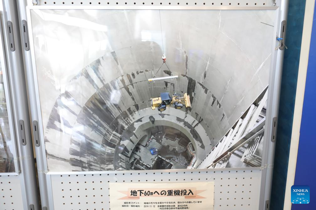
This photo taken in Japan's Saitama Prefecture on March 26, 2024 shows a picture in which a vehicle is being transported through the shaft down to the Metropolitan Outer Area Underground Discharge Channel.(Xinhua/Zhong Ya)


