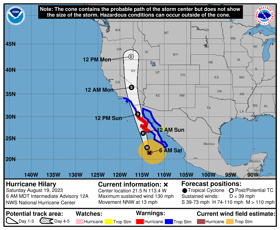
The U.S. National Hurricane Center and Central Pacific Hurricane Center posted this map on Aug. 19, 2023 to show the tracks of Hurricane Hilary. (Map courtesy: The U.S. National Hurricane Center)
Life-threatening and potentially catastrophic flooding is likely over much of southern California this weekend and early next week, with Los Angeles, Las Vegas, and San Diego in the high-risk area.
LOS ANGELES, Aug. 19 (Xinhua) -- Hurricane Hilary, now a Category 4 hurricane barreling north, is expected to impose "significant impacts," including heavy rain and flooding, on the U.S. Southwest this weekend into early next week, according to the U.S. National Weather Service (NWS).
The U.S. National Hurricane Center (NHC) on Friday issued for the first time a tropical storm watch for parts of Southern California, warning against possible threat of tropical conditions in the areas within 48 hours.
Hilary intensified rapidly Thursday into Friday from a tropical storm on Mexico's Pacific coast to a Category 4 hurricane, with a maximum surface wind of 209 to 251 km per hour. NHS expects Hilary to land in Southern California on Monday at midnight (GMT 1600 Sunday) as a tropical storm after weakening on the west coast of the Baja California Peninsula on Saturday.
Rainfall impacts are expected to peak over the weekend, while the threat of strong wind continues to increase for portions of the U.S. Southwest, especially in the mountainous areas, according to the NWS.
The NWS issued a Flood Watch on Friday, as several cities in southeastern California in the current path of the storm are below sea level. Some regions are currently forecasted to receive up to 5 inches of rain during the next five days.
Life-threatening and potentially catastrophic flooding is likely over much of southern California this weekend and early next week, with Los Angeles, Las Vegas, and San Diego in the high-risk area.
Very strong winds will cause hazardous seas which could capsize or damage vessels and reduce visibility, according to the NWS.
Officials requested mariners to consider altering plans to avoid possible hazardous conditions.
NWS Director Ken Graham asked residents to take this storm seriously. "NWS is carefully tracking Hurricane Hilary and the dangerous weather it's expected to bring to Mexico and the southwestern U.S.," he tweeted.
"This is not like the other storms we've experienced. It's a huge footprint, it goes all the way from the desert out into the ocean," said Chris Heiser, executive director for the Office of Emergency Services in San Diego. ■


